Integration of system dynamics models and geographic information systems for the management of the environmental system
-
Coordinator
Prof Gerardo Toraldo - University of Naples "Federico II" -
Description
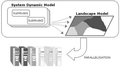
In the management of environmental system, hardware and software tools are becoming more and more effective as monitoring and forecasting tools. The large amount and the heterogynous of the information to be considered, as well as the need to have quick answers for any decision system, require effective software able to use the computational powerful of the new systems of machines now available (GRID computing). In the environment system management, one of the key points is the effective integration between spatial information such as geographic maps, and dynamic information and process The problem of integration between temporal models and Geographic Information Systems (GIS) involves theoretical and technical aspects. Many GIS software are advertised in terms of their modeling capability but such modeling tools are often unable to handle a full integration of spatial and dynamic process. In this project a new software tool named SimARC will be developed and tested to interface models created by system dynamic software SIMILE with ArcView (E.S.R.I. Inc.) GIS environment. The tool enables users to link a model to input data from the GIS database. This essentially amounts to running a model in each polygon element of the ArcView map with inputs from layers of the relative shapefile and creating new GIS layers from any selected model output variable. So, considering the capability of both SIMILE system dynamics software and of ArcView GIS tool, we believe it can be very useful to lots of users. The advantage of using a new dedicated spatial tool instead of an established GIS package lies in its enhanced modelling capabilities, i.e. the possibility of making use of temporal simulations at both local and spatial scales in a highly integrated way. This approach from modularity of a system dynamic and spatial information of a GIS will be use also for different scales problems, useful also the gDSS (generic Decision Support System). So the application of this new integrated modelling software should be very useful for the application of models to complex and spatial ecological problems. Moreover for the use of this new system, it will consider the computational cost in computing terms and the different nature of inputs (maps, models, data stream information for models, etc etc); for this reason we believe that computational problems which can arise from complex simulations will be dealt with as a scientific problem in its own right, by the implementation of advanced GRID computing methods for more efficient computational load and data distribution. These technologies will be critical in scaling models of complex ecological processes up to spatial scales. -
Founded by
Regione Campania -
initial/final proposal
01/03/2006-2007 -
Staff
Francesco GIANNINO (internal responsable)
Stefano MAZZOLENI -
Reserach associated
Modelling software development -
Grant amount
€ 58.000,00